Reliable habitat maps sit at the heart of biodiversity monitoring, natural capital accounting and nature recovery planning. Recent policy developments in the UK have made this even more important. The UK Land Use Framework highlights the need for a coherent national land-use evidence base and better integration of spatial data across sectors. However, producing consistent habitat maps at large scales is not straightforward. Field surveys provide detailed ecological information, but they are expensive and cover limited areas. Remote sensing can map land cover over large regions, but it often relies on large training datasets and does not always produce outputs that align with ecological classifications used in planning. In our recent study, we explored an alternative approach. We evaluated EcoservR, an open-source, rule-based habitat mapping toolkit developed at the Natural Capital Hub, Liverpool John Moores University. EcoservR uses existing spatial datasets and a set of transparent rules to produce habitat maps that are consistent and reproducible at landscape scale.
Why this matters
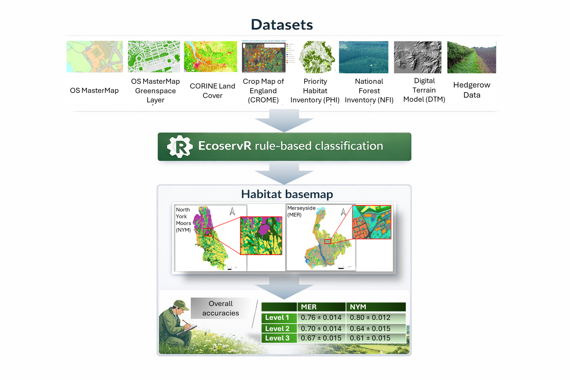
Environmental decisions increasingly depend on understanding where habitats are and how landscapes are structured. In England, initiatives such as Local Nature Recovery Strategies rely on this type of information to prioritise restoration and guide investment. This creates a practical challenge: decision-makers need habitat maps that are not only accurate, but also consistent and compatible with existing planning frameworks. EcoservR addresses this by combining widely available datasets, including OS MasterMap, the Priority Habitat Inventory and agricultural land-use data, using a rule-based classification approach. The outputs align with the Joint Nature Conservation Committee Phase 1 habitat classification, which is widely used in ecological surveys and planning. This means the maps can be used directly in ecosystem service assessments and spatial planning workflows.
How we tested the approach
We tested EcoservR in two very different landscapes in northern England:
- Merseyside, a complex urban and coastal environment
- North York Moors, dominated by upland grasslands, heath and woodland
We compared the mapped habitats with independent ecological survey data. Where there were differences, we checked high-resolution aerial imagery to understand whether these were genuine errors or reflected real changes in the landscape.
What we found
EcoservR performed well when mapping broad habitat types. Overall accuracy ranged from around 61% to 80%, depending on the landscape and level of detail. Habitats with clear physical structure, such as woodland and open water, were mapped reliably. As expected, performance decreased at finer levels of detail. Semi-natural habitats were particularly challenging. For example, distinguishing between improved and unimproved grasslands proved difficult, as available datasets do not fully capture differences in management or species composition. Similar issues arose for heathland and mire habitats, where subtle environmental gradients are not easily detected. One of the most interesting findings came from the validation process. Around one-third of the differences between the model outputs and survey data were not errors in the mapping itself. Instead, they reflected either changes in the landscape or uncertainty in the original survey data.
What this means for practice
Our results suggest that rule-based mapping can provide a reliable and transparent way to produce habitat maps at regional scale. Because EcoservR generates vector habitat polygons aligned with standard classifications, the outputs can be used directly in ecosystem service models, biodiversity assessments and planning tools. At the Natural Capital Hub, we use this type of approach as part of a wider workflow linking habitat mapping with ecosystem service assessment and natural capital accounting. These outputs help identify priority areas for restoration and support evidence-based decisions on environmental investment.
Looking ahead
There is clear potential to improve this approach further. Adding information on vegetation structure, soils or LiDAR data could help distinguish between similar habitats. There is also scope to combine rule-based mapping with remote sensing. In Scotland, for example, remote sensing–derived land cover products are used within NatureScot’s Natural Capital Tool to refine rule-based habitat maps. These data can subdivide large habitat polygons into smaller patches, improving the representation of mixed and transitional habitats while keeping a consistent spatial structure. Emerging machine learning approaches may also play a role, particularly in generating detailed features from high-resolution imagery. Rule-based systems are likely to remain important because they provide a transparent and consistent framework for organising spatial data.
Read the full article ‘Evaluating the accuracy of the EcoservR toolkit forfine-resolution habitat mapping’ in Ecological Solutions and Evidence.