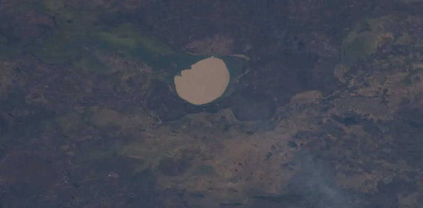
Lake Iro in Chad was in the news in early August 2025 after a picture taken by a NASA astronaut was published showing it looking like a large, circular silver mirror as sunlight reflected off its surface and into space. The phenomenon is known as a sunglint and can happen to any water surface under the right conditions. The startling picture led The Conversation Africa to find out more about the lake. Pierre Rochette is an emeritus professor in geophysics from Aix-Marseille University in France. He has studied the lake, and navigated it too for a geophysical study. He answers questions about its properties as an impact crater from an ancient meteor.
What’s there to know about Lake Iro?
The lake is in south-eastern Chad, about 120 km from the border with the Central African Republic.
Lake Iro lies in the middle of an “inland delta”, which was formed by river waters diverging from the Bahr Salamat, a river which flows in the wet season, with very limited flow in the dry season.
It has a semi-circular shape and is about 12 km in diameter. A number of rivers meander around it.
Iro Lake is a vital resource for people living in the area. It provides permanent water and fodder for the large herds of cattle migrating from the Sahelian zone when it’s too dry to keep the animals up north.
People there also produce dried smoked fish, which is exported.
What’s unique about the lake?
Iro may be the largest extraterrestrial impact crater lake in Africa. Volcanic or karstic (where rock has dissolved) crater lakes are much more abundant on Earth.
When an asteroid or comet strikes the Earth’s surface at a speed of about 10km per second, it excavates a crater about ten times larger than itself. So the extraterrestrial body must have been 1km wide in the case of Iro Lake.
My research shows several examples of such impact craters in Chad. Their age is unknown, but likely older than ten million years.
The crater that is home to Lake Iro is a bit larger than the better known Bosumtwi Lake in Ghana. Bosumtwi crater was also excavated by an asteroid strike, but more recently, about one million years ago.
Africa has only 20 proven impact craters (among which seven have a diameter larger than 10km). That corresponds to one tenth of the total proven craters on Earth.
Since 2014, no new crater has been discovered in Africa. A large number (around 49, according to some studies) and a few other potential impact structures have been proposed in Africa, mostly based on satellite imagery and topography.
But solid proof for impact in these proposed structures, including Iro lake, is lacking due to limited or non-existent field studies.
As a group of scientists we have been heavily involved in tracking down impact craters on the continent. Our most recent work involves an ongoing study of the 40km diameter Velingara structure in Senegal.
Studying large impact craters is important to better evaluate the future threat of asteroid impacts. They also provide potential resources (like water, petrol and metals) and a record of ancient climates in the sediments accumulated in the crater lake.
How do you know it started off as a meteor crater?
Proving the impact nature of a circular structure requires traces of either extraterrestrial matter or of very high pressures endured by the target material.
Due to the likely old age and thus strong erosion of Iro’s circular depression, hardly any rock can be found on the surface. Only drilling for several hundred metres can reach the impacted rocks and thus provide definitive proof. This is a very hard task in such a remote area.
Nevertheless, the known geological features of the area provide no other explanation for the presence of this circular depression, apart from an impact.
That’s why we consider Iro Lake as a potential impact structure. It’s still unproven, but likely.
What are its distinctive geological features?
The area around Iro is extremely flat, as demonstrated by the slope of the Bahr Salamat river, south of the lake, of the order of 0.2 metres per kilometre. This explains the meandering nature of the river, highlighted by the published sunglint image.
Bahr Salamat’s altitude south of Iro is 396 metres, higher by only 40 metres from its altitude 160km to the west-south-west. In fact the Bahr (“river” in the local language) seems to go around the Iro lake depression (the average altitude of the lake is 387 metres).
This is odd as the river should have been attracted towards the depression, but can be explained by the fact that the impact generated a regional uplift that resulted in the Bahr changing its course to the south, to avoid the uplifted region.
What is a sunglint?
Depending on the angle of view, any body of water can behave as a mirror for a light source, such as the sun.
Completely still water just reproduces the object emitting the light, like a perfectly still mountain lake reproduces the rocky landscape above it.
But if the water surface is disturbed by wavelets, the perfect reflection vanishes, and is replaced by blurred light – in this case from the sun. This is the sunglint.
Anybody can experience it in clear weather from an aeroplane or from the top of a mountain, looking at a landscape containing water surfaces riddled by a breeze, in the direction of the sun.
Spectacular examples of sunglints, especially when the sun is not at its highest point (at noon), are reported from satellite imagery, as can be seen here.
The visual phenomenon is not limited to satellite imagery. The term sunglint has been in use since the 1960s. Earlier mentions of the phenomenon used the term “sun glitter”.
![]()
Pierre Rochette receives funding from Agence Nationale de la Recherche (French ministry of Science), ET-Megafire grant ANR-21-CE49-0014-03. His mission to Iro lake was supported by the University of N’Djamena in Chad, as well as the Institut de Recherche et Développement (IRD)