Shortlisted for the Georgina Mace Prize 2022
In their latest research article, Luke Potgieter and colleagues developed a strategic, spatial prioritization approach for identifying sites most vulnerable to new or expanding terrestrial non-native plant invasions in urban landscapes.
Cities have historically been under-studied in ecology and have not seen sufficient development of conservation and biodiversity management policy. This dearth of urban-focused applied ecology and conservation work has left a major gap that impacts the ability for municipal agencies to deal with difficult ecological problems as well as opportunities in urban areas.
Urban biological invasions
Cities are hubs of non-native species introductions. As the world’s human population becomes increasingly urbanized and globally connected, the influx of non-native species into urban areas will continue to increase.
Many non-native species are well-adapted to urban living and can invade urban ecosystems, and natural areas within and surrounding towns and cities. The impact of invasive species on biodiversity and ecosystem services is becoming more significant, highlighting the need for effective strategies to mitigate their effects.
There are, however, few widely adopted, standardized approaches for prioritizing sites vulnerable to species invasions in urban areas.
Prioritizing important sites for conservation
In our study, we applied multi-criteria decision analyses and spatial modelling techniques to develop a transparent, repeatable, and spatially explicit approach for identifying sites vulnerable to the effects of non-native plant invasions in urban areas. To test this approach, we used the Toronto region as a case study, the most populous metropolitan area in Canada and one of the fastest growing urban centres in North America.

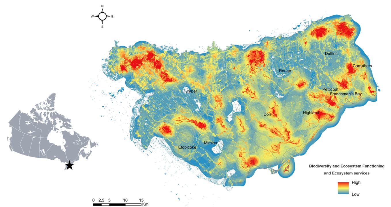
Through consultation with local conservation authorities, we developed a hierarchical set of 19 criteria grouped into two categories: biodiversity and ecosystem functioning, and ecosystem services. Spatial data layers were assigned to each criterion and used to map areas most important for biodiversity and ecosystem functioning and providing ecosystem services.
High priority sites identified by our prioritization model included areas of significant biodiversity conservation value such as intact forests, meadows, and wetlands which are crucial for providing regulating and supporting services. Other high-priority sites included areas for non-material benefits such as recreation, education and heritage value.
A case-study: Dog-strangling vine
We overlayed these priority areas with distribution data of dog strangling vine (Vincetoxicum rossicum, DSV), one of Toronto region’s most widespread and damaging invasive non-native plant species, to determine the potential threat species’ invasions pose to these important areas.
The distribution map of DSV showed that these high priority sites are heavily invaded (92.9% of the area occupied by V. rossicum comprises medium-high priority sites) and should be prioritized for management to ensure biodiversity and ecosystem functioning, and the provision of ecosystem services are maximized.

There is an urgent need to protect and manage areas where biological invasions will have the greatest socio-ecological impact, and limited resources call for the strategic prioritization of these areas. This spatial prioritization tool provides researchers and agencies with a sound, transparent and repeatable approach to allocating resource for species management in complex urban landscape.
Read the full article: “Prioritizing sites for terrestrial invasive alien plant management in urban ecosystems” in Issue 3:3 of Ecological Solutions and Evidence.
Discover the other early career authors shortlisted for the Georgina Mace Prize 2022.
