Abigail Feuka discusses how she, alongside colleagues, employed three surveillance methods to estimate the probability of presence and spread of a low-prevalence pathogen at a landscape scale under incomplete sampling coverage.
Wildlife disease
The COVID-19 pandemic has brought disease transmission from animals to humans into the public spotlight. But studying wildlife disease can be tricky, especially low prevalence diseases, where proportionally few individuals in a population test positive. For these diseases, many samples are needed to determine if the disease is present in an area or population.
But, if not many individuals in a population are infected, is the disease really that dangerous? The answer depends on the pathogen and its risks: when it comes to pathogens that cause chronic, potentially fatal (if untreated) illnesses that are transmissible between wildlife, livestock, and humans, the risk to human health and food production is high.
Bovine tuberculosis
This is the case for livestock producers, hunters, and wildlife managers in northern Michigan, USA living where bovine tuberculosis (or bovine TB) is endemic, or regularly occurring. Bovine TB is a slow-progressing infection that affects the lungs and is transmissible to deer, cattle, and humans via close contact or the consumption of unpasteurized dairy products.

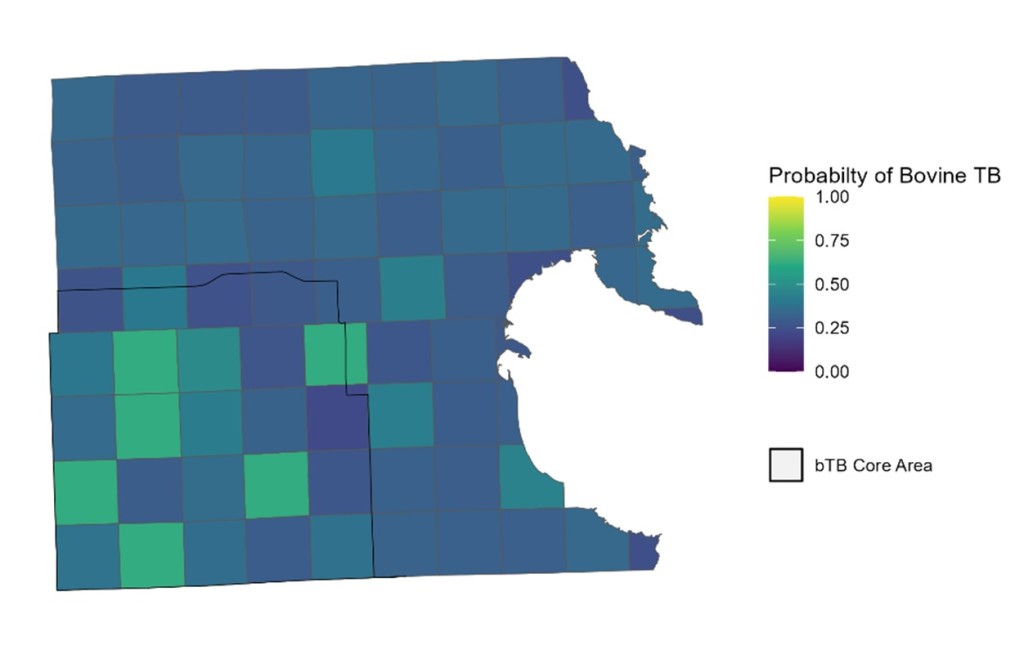
Within the five-county area encompassing Michigan’s bovine TB endemic zone, only 4 to 12 deer per one thousand sampled tests positive for bovine TB. Despite this low rate of positive cases, our research team wanted to determine spatial risk of bovine TB in Alpena County, at the center of Michigan’s bovine TB endemic zone. By mapping out where bovine TB is most likely to occur, we aimed to provide a tool to help wildlife managers target actions that slow and prevent bovine TB spread.
The study
To do this, we used bovine TB testing results from over ten thousand deer obtained through numerous sources, including samples from hunters, who voluntarily submit their deer heads to the Michigan Department of Natural Resources for testing, and from the U.S. Department of Agriculture, who use disease control permits to remove deer on private property as a form of disease management. The remaining samples were obtained opportunistically, such as roadkill deer or from landowners using crop damage permits to remove deer from their property.

We divided up Alpena County into a 25 km2 grid to map probabilities of bovine TB in the deer population at a landscape scale. With multiple deer sampled within a grid cell, we could determine how effective each surveillance method is at detecting bovine TB in the population at this spatial scale.
Findings
We found deer removed by agency professionals were least likely to be positive for bovine TB (1% chance), and deer removed via public harvest were most likely to be positive (3% chance). This could be because hunters are able to use public and private land, depending on their permit, allowing them to sample more of the landscape than agency professionals, who only obtain deer from cattle farms enrolled in a bovine TB mitigation program.
Areas with greater estimated deer density had an increased likelihood of being infected with bovine TB. Spread was relatively slow at a landscape scale, with an 8-27% chance of bovine TB spreading into a 25 km2 area, depending on deer density. As expected for a slow-progressing, chronic disease, our analysis showed bovine TB has high staying power: there was a 66% chance of an area continuing to have bovine TB if it was positive the previous year.

These results indicate areas with greater deer densities have the highest risk of bovine TB spreading into them and could be good targets for biosecurity measures. Additionally, we can generally expect bovine TB to remain in areas where it existed previously, and not blink out of a deer population on its own.
Finally, we found that using multiple surveillance methods improved estimates of disease spread. Our study demonstrates the importance of using all data available to create better models of disease spread that inform management actions.
The Michigan Department of Natural Resources can use these maps to determine what areas are good candidates for increased numbers of deer hunting permits to reduce bovine TB spread and target sites for trials of deer vaccination. The state’s Wildlife Risk Mitigation program can use our results to prioritize which cattle producers could most use a deer fence around their property.
Assessing wildlife disease risk can be difficult, but having tools like our model to help quantify potential risk can help inform effective resource allocation to manage disease spread to livestock, wildlife, and people.
Read the full article “Estimating landscape spread of a low-prevalence disease using multiple surveillance methods” in Journal of Applied Ecology
